Ecotourism, National Parks
Cooloola Great Walk, Great Sandy National Park
Mar
Cooloola sand mass
A veritable playground for adventure lovers, the Cooloola Recreation Area of Great Sandy National Park truly offers it all, from surfing Double Island Point, to camping, fishing, and my favourite pastime, hiking. The combination of offerings and proximity to major centres make Cooloola one of the most popular destinations in South East Queensland.
Cooloola derived its name from the Aboriginal name for cypress trees ‘Kululu’. Cypress trees once flourished through Cooloola Recreation Area. However, when early settlers moved in the cypress were logged and now very few remain.
Nature, however, has an incredible way of overcoming such events and the Cooloola Recreation Area we see now is enchanting with an ever-changing landscape through rainforest, tall eucalypt forest, dry coastal woodland, heath plains and even across some sandy plains.
To fully understand how truly amazing this region is, the best way to experience it is on the Cooloola Great Walk. This 5-day hike through the Cooloola region of the stunning Great Sandy National Park will challenge you and amaze with stunning views.
The near 100km hike starts out from the incredible Carlos Sandblow at Rainbow Beach where it’s goodbye to civilisation for a few days.
Day 1
Starting at the northern end of Cooloola Great Walk in Rainbow Beach, within minutes you reach the magnificent Carlos Sandblow which is a part of Cooloola sand mass where weather conditions have transformed a forest into a ‘moonscape’ of sand covering 15 hectares. This incredible sandy visage combines with spectacular views over Rainbow Beach, Double Island Point, and Tin Can Bay.
 Poona Lake
This 15.2km section of the hike gives a very good taste of the conditions for the next 4 days. A drop down in elevation during the last quarter of the day takes you to Poona Lake, 12 hectares of fresh water set amongst the bushland. When the air is still, the reflections off the water are stunning. It is a photographer’s dream with the contrast of the tannin-stained water against the white sand, and a great spot for a break.
Poona can also be accessed as a 2km hike from Bymien Picnic Area if you are not up to the full Great Walk.
After Poona Lake you drop down gradually about 90 meters of elevation. Then it’s well UP at an angle that feels similar in inclination to the trajectory of a NASA launch. Take it slow and steady and let the magical sounds of the lush rainforest envelop you.
That evening sleep at Kauri Walkers Camp – named for the kauri pines growing in the region. It is hidden away in an area that feels a million miles from anywhere, deep in the rainforest.
This campground is generally the busiest of all four campgrounds due to its proximity to Rainbow and Teewah Beaches, providing a great opportunity to catch up with fellow hikers and shoot the breeze over dinner before retiring for the night.
Day 2
One of the more challenging days both physically and mentally, being 20.5km, it is the longest of the days. You will travel mostly through rainforest full of strangler figs, massive Kauri pines and plentiful wildlife before coming across Lake Cooloomera just north of Litoria Walkers Camp.
Lake Cooloomera, whilst pretty, is not a place to swim, with snakes plentiful in the reeds as well as being home to many ‘acid frog’ species and birds.
About 600m uphill past the lake lies Litoria Walkers camp. Litoria – meaning ‘shore’ or ‘beach’ – is the name given to Australia’s largest genera of frogs. The high-pitched sounds of the Cooloola sedgefrog (Litoria cooloolensis) who have adapted to the acidity in the nearby lake may be heard.
 Cliff view during the Cooloola Great Walk
Day 3
A day full of rapidly changing landscapes, from rainforest beside the beach to swamp as you near the Noosa River. Experiencing these changes over such a short distance helps you really appreciate how nature responds to slight environmental changes.
Keep an eye out for Ramsey’s hut along the way, an old timber cutters hut which was abandoned prior to the region being classified national park in 1975… look but do not touch.
Dutgee (the Aboriginal word for boronia shrubs which grow through Cooloola) Walkers Camp is on the Noosa River, making a fantastic way to mark the middle of Cooloola Great Walk with a swim, if you are game.
Day 4
What an incredible day despite it being the second longest day. A nice and easy start to the day with a flat walk along the banks of the Noosa River is a stark change in landscape to the previous days’ landscape. The contorted shapes of the trees native to the low-lying flats of the Noosa River are beautiful in a macabre kind of way. It is a spectacle to behold for sure.
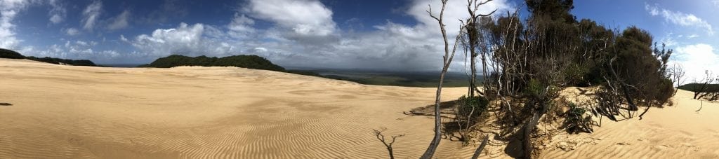
Up into the hills again with a climb of about 190 meters and then BAM, the Cooloola Sand Patch…wow! This mini desert, complete with its own oasis has to be seen to truly appreciate it. It is a 1km hike to get across it… thankfully mostly downhill when heading north to south.
After crossing this desert, it’s back into the bush and a long walk through valleys between massive sand dunes with constant presentation of viewpoints in differing directions and incredible breezes to the final camp of the trip, Brahminy walkers camp.
It is a great spot with a picturesque view of the sunset over Lake Cootharaba to the west, the sunrise over the Pacific Ocean to the east, and infamous Noosa in the south from the common area. Definitely a favourite camp spot and an incredible place to spend the final night.
Day 5 – The last day
17.3km to go and it’s almost all downhill to the pub from here!
Despite the elevation not being anywhere near as high as it is on any of the previous days, the views and sounds of cars driving along the beach gently re-introduce the modern world. You will initially travel through lush rainforest before hitting the sand for a short section and back in through the coastal heath plains of Arthur Harrold Nature Reserve.
Giddy with achievement, head to the pub, pull up at a table out the back so as not to scare other patrons and settle in for the best feed you have had in days and a well-earned beverage.
The author has endeavoured to ensure that the information presented here is as accurate as possible. However, they or NPAQ do not accept responsibility for any loss, injury or inconvenience sustained by any person guided by this article.