Protected Magazine
Moments In Time – End 1953
Nov
The following was taken from the 1953 October & December NPAQ newsletters.
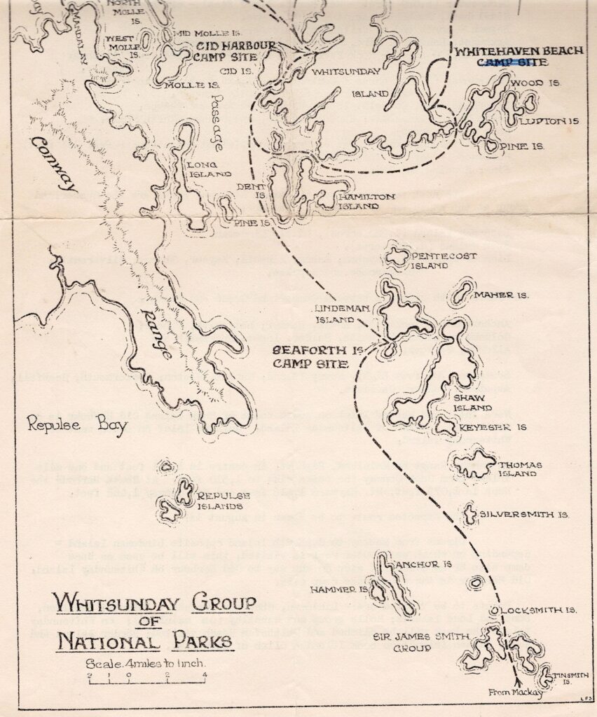
The National Parks on and off the Queensland Coast between Bowen and Mackay.
This map (below) is issued on the occasion of an extended field outing by 57 members of the National Parks Association of Queensland to the Whitsunday Island group of National Parks (two weeks) in August, 1953. May it prove of use to those unable to take part in this visit as well as to the participants.
63 Islands are included in a National Park group contained in County Herbert. With Conway Range National Park (on the mainland shore of Whitsunday Passage), the area of the reserves in the group is 114,467 acres. They were gazetted between 1936 and 1944. Island National Parks off the coast of Queensland occupy 212,000 acres.
The names of more of the Island reserves are: –
* Gloucester (6,080 acres – Mt Bertha 1,870 ft) – off Bowen.
* Saddleback, Gumbrell, Armit & Double Cove.
* Hayman – north end of Whitsunday Passage.
* Arkhurst, Langford, Bird, Black (adjacent to Hayman).
* Hook (12,800 acres – Hook Peak 1,478 ft) – north section Whitsunday Passage.
* Whitsunday (27,000 acres – Central Peak 1,426 ft) – principally eastern barrier of Whitsunday Passage.
* Deloraine, Esk, Dumbell, Ireby, Harold, Edward and Teague.
* South Molle, Mid Molle, Shute, Planton, and Denham, North Molle.
* Long (2,085 acres).
* Border (volcanic mass) east of Whitsunday Island (Mosstrooper Peak 757 ft) Haslewood – east of Whitsunday Island.
* Pine, Henning and Cid.
The next southern group of Island National Parks are the Cumberland group at the south end of Whitsunday Passage: –
* Lindeman Island (1,920 acres), Little Lindeman.
* Shaw Island (4,100 acres).
* Lion or Pentecost, Baynham, Maher, Mansell, Keyser, Thomas, Silversmith, Blackcombe and Repulse.
Sir James Smith group is between Cumberland Group and Mackay: –
* Achorsmith, Blacksmith, Anvil, Hammer, Ladysmith, Pincer, Goldsmith, Linne, Tinsmith, Solder, Ingot, Locksmith and Allonby, Bellows.
* Brampton (700 ft high), Newry Island, Rabbit, Wigton, Cockermouth, Scawfell, Aspatria, Calder, Carlise.
Nara Inlet and Mocona Inlet on south coast of Hook Island Cid Harbour is on northwest section of Whitsunday Island. Gulnare Inlet on southwest of Whitsunday Island.
In Conway Range on Mainland, High Mt, in centre is 1,841 ft and one mile inland from Cape Conway the peaks rise to 1,510 ft. At Shute Harbour, the Hump is 1,079 ft, Mt Hayward 1,418 ft and Mt Conway 1,468 ft.
The expected route to be taken in August is: –
Direct from Mackay to Seaforth Island opposite Lindeman Island – depending on which week outer reef is visited, this will be used as base camp site or as overnight stop on the way to Cid Harbour on Whitsunday Island. Cid Harbour is the other base camp site.
Points to be visited are: –
Lindeman, Shaw and Pentecost Islands; Hamilton, Dent and Long Islands; Molle group and Mandalay (on mainland); on Whitsunday Island the Peak will be climbed and Whitehaven Beach visited; Border Island and Reef; Hayman Island; on Hook Island a climb of Hook Peak.