Protected Magazine
Supplementing National Parks
Feb
National parks have proved to be an integral part of society worldwide. In Queensland, “There is increasing demand for access to national parks for a range of tourism and recreational purposes” (NPAQ Protected Issue 34, 2021). But “Queensland has long suffered from an under-investment in conservation and land management” (NPAQ Protected Issue 23, 2018).
This begs the question: If park legislation is inadequate to deliver sustainable outcomes, what else can be done to convey government policy directives in the community’s interest? This can only be answered by demonstrating results achieved through the private sector.
The most recent authoritative book on environmental conservation in the home of the national park movement (USA) concludes: “Threatened and endangered species simply cannot be recovered without private landholders providing assistance in the form of habitat protection….It is the responsibility of the community to manage the environment.”
A field experiment was begun in 1990, following the nomination of a set of ‘core areas’ across Queensland for the purposes of the (forestalled) QZOO Concept. Field observations were later refined to confirm that the alluvial plain at the mouth of the Burdekin River – Queensland’s largest river basin – was indeed of leading priority for conservation management attention.
This 130,000 square kilometre area lies east of the coastal hills of the Great Dividing Range, which the river breeches to enter the flood-prone delta.
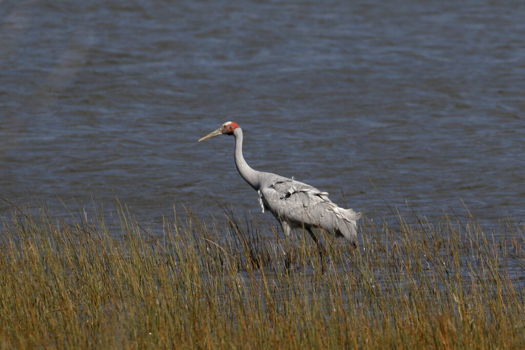
Surrounded by RAMSAR-designated National and Conservation Park lands (see Bowling Green Bay National Park, Protected Issue 35, 2022), the central area of ‘Wongaloo’ is the habitat of tens of thousands of waterbirds – most importantly, the emblemic brolga.
‘Wongaloo’ is midway between Townville and Ayr. The site is an outstanding example of a lacustrine wetland on a postgraded tropical coast. It is almost entirely occupied by a shallow freshwater lake during most wet seasons. It tends to become brackish when evaporation accumulates salt of marine origin; the lake area shrinks and often disappears.
Bulkuru sedge covers much of the wetlands and is a key food for the principal Australian populations of the brolga. Magpie geese are also abundant, again feeding on the bulkuru seeds and tubers as the waters recede. Other waterbirds are commonplace seasonally. Crabs, fish, estuarine crocodiles and much other wildlife occur.
A backdrop to the wetlands is provided by the imposing Mt Elliot Range (national park). Its watercourses of St Margaret’s Creek, Emmet Creek and McKenzie Creek fan into the wetland and are bordered by evergreen forest giving way to eucalypt woodland and open grasslands nearer the water. On the coastal front of the wetlands and saltpans, mangrove forests abut the Coral Sea (Pacific Ocean).
The area’s historic use was first described by James (Jimmy) Morill, following 17 years of living among the Aborigines after being shipwrecked there. Subsequently, the land was used for beef cattle production, and there was later collaborative maintenance of the wetlands between the landowner and the Townsville Gun Club.
Some of the large flocks of waterfowl that congregate on Wongaloo Regional Park wetlands in post-wet seasons.
Between 1990 and 1997, a wide range of environmental, legal, community and economic reports were commissioned by an eight-person private Steering Committee. With a view to the sites eventually chosen appealing also to international audiences, advice was sought on Terms of Reference consistent with the discipline of the U.S. philanthropy business category.
These were successfully instituted in 1999, with registration of The Wetlands and Grasslands Foundation (WGF) to address the long-term management of most productive but least reserved ecosystems.
Among its objectives – including preservation of one of Australia’s most iconic emblems (the brolga or native companion) – Wongaloo Conservation Park aspires to serve its regional community as a major environmental bank. In this case, the modelling is aiming to introduce scale and State-wide priority to environmental ‘offsetting’ – in the course of the further development of the city of Townsville.
In 2016, WGF was jointly appointed Trustee and manager of the park by the State Government. WGF Membership is widespread and continues to increase.
By 2010, a total of AU$2.5 million had been raised from Queensland Government, Townsville City Council, Burdekin Shire Council, the National Reserves Scheme, and private and Member bequests.
This fund was then used to purchase the 21 lots (2,060 hectares) of core wetland habitat, later (in 2010) officially gazetted as Wongaloo Regional Park. An adjoining 4.8-hectare freehold parcel also was obtained in the name of the WGF for education, parking and ancillary functional uses.
Under the supervision of an Honorary Director (Mark Stoneman, resident nearby), management of the dynamic wetlands and adjacent upland ecosystems began in 2010 – all in terms of the Wongaloo Regional Park Management Statement 2015.
At this juncture, key management activities involve removal of exotic aquatic weeds (most effectively by cattle according to several definitive scientific studies, along with strategically placed fencing), prevention of further invasion of the exotic noxious weeds in the adjacent Parks, modification of saline intrusions by dams, and prioritization of management of different ecosystems.
The issue of aquatic weed control by cattle: brolgas throughout the stocked pastoral wetlands in 1958 and the same area as Conservation Park destocked and choked by para grass in 2019 (below).
The area is divided (towards the west) by the Pacific Highway and the Great Northern train line. Crossing this line for the purposes of access for visitors remains another on-going problem to be resolved. Management envisages visitation where access is scaled to the seasonality both of the wetlands and the observer’s potential experience. This would recognise the need for nominated access periods and seasonal staff.
Specialist management advice has continued to be gleaned on-site from such authorities as Dr Geoffrey Matthews (co-author of the RAMSAR Convention), Dr David Challinor (Smithsonian Institution) and Roger Jaensch (Asia/Pacific Wetlands International).
Benchmarking of on-going progress is by way of a comparable project in Victoria (Heart Morass in Gippsland), where sporting gun clubs have coordinated using the alternative charity category of organization.
In the proposed education centre, a research library in close collaboration with its adjacent Australian Institute of Marine Science and with James Cook University in Townsville is aimed to be devoted to the practical importance of housing field information over the long term.
Concept planning for visitor access and facilities such as observation points (above left), the latest report on management progress at Wongaloo Regional Park (above centre) and an overview of Queensland placing very high priority on the Burdekin delta wetlands (above right).
The essential difference of this serious on-going endeavour lies in its unprecedented approach in Australia as a Profit-for-Purpose organization – with environmental management undertaken as a business rather than one more dependent on charity (taxpayer or otherwise).