Protected Magazine
Using Technology to Support Conservation Outcomes
Feb
Accurate and regular and monitoring is fundamental to wildlife conservation. If we don’t know what animals are in an area, and how many there are, it is difficult to manage them or the area well. Even obtaining a baseline for species’ abundance can be hindered by the cost and logistics of collecting the data in the field. Traditional methods for gathering such data are usually labour-intensive and involve trained experts walking through the scrub and making direct observations. With ever greater pressure on conservation budgets, finding more efficient methodologies for data collection is essential.
Methodologies that combine the use of imagery collected from aerial platforms (either manned aircraft or unmanned drones), together with sophisticated analytical tools such as artificial intelligence (AI) algorithms, are revolutionising wildlife and vegetation monitoring. Such methods enable large areas of terrain to be covered in a relatively short time and can produce more accurate results than manual surveys. Importantly, the use of technology also creates a digital record that can be archived and accessed into the future.
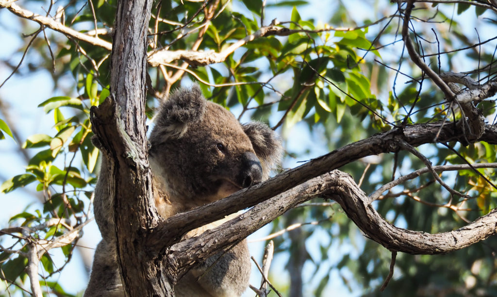
Queensland University of Technology has been at the forefront of developing these high-tech methods for conservation. Associate Professor Grant Hamilton and his team were the world first to pioneer the use of drones and AI for the detection of koalas in the complex environments in which they live. They are now extending this methodology to detect deer, macropods and a range of other species.
Conducting surveys using drones allows for large areas to be covered quickly, and processing the data collected using AI algorithms means a much more rapid and accurate analysis than can be achieved by people alone. Our goal is to support conservation by providing land managers with the tools to make informed decisions about the preservation of the habitat.
One of our most recent projects was an assessment of vegetation structure and koala abundance for the Yurol-Ringtail State Forests Conservation Project. This project is one of the most significant recent conservation developments in South-East Queensland. It is a collaboration between the Queensland Government, the Kabi Kabi people, Noosa Council, HQPlantations and Noosa Parks Association with the aim to convert 2,400ha of Kabi Kabi country that is currently state forest into a national park by 2027. The creation of this national park will allow the preservation of valuable habitat for many threatened and endangered species of birds and animals. In order to transition these valuable areas, historically used as a timber plantation, into a national park, it is crucial to establish a baseline for the vegetation structure and animal distribution in both locations.
To assess the vegetation structure of Yurol and Ringtail State Forests, the team conducted remote sensing surveys to quantify vegetation height and canopy cover. Images were collected using a light aircraft equipped with a high-resolution camera. The aircraft flew transects over the study area, collecting many overlapping images of the terrain and vegetation. Using GPS coordinates, all images were geo-referenced (linked to an exact location on the map) and compiled into an orthomosaic – a very high-resolution image reconstruction of the forest (like Google Earth, but much more detailed). Because images of the vegetation were taken from different angles, automated algorithms could be used to create a 3D model, representing the terrain and height of the vegetation above it. The resulting canopy height model provided a precise baseline of the vegetation structure in Yurol and Ringtail State Forests, which is extremely important for the future monitoring of vegetation recovery during the transition to national park. As some of these areas are still currently used as timber plantations, monitoring vegetation rehabilitation and regrowth is critically important to ensure that habitat is recovering.
In addition to the vegetation assessment, our team conducted koala population surveys using drone-based thermal imagery. Koalas as well as other animals stand out in the imagery because they have a higher body temperature than the surrounding vegetation. Our artificial intelligence algorithms have been trained to automatically recognise koalas in thermal drone footage and the precision of detections is higher than that of the ground-based surveys. Different colours denote vegetation height, red being the higher value.
Projects such as the Yurol-Ringtail vegetation and koala survey highlight the importance of using cutting-edge technology in conservation efforts. An assessment of this scale and precision could not be rapidly achieved using land-based survey techniques.
Additionally, this methodology is repeatable down to using the same drone flight paths, which allows conservation managers to conduct regular monitoring of vegetation and analyse its trends. We are continuing to develop new algorithms to analyse remote sensing data to more efficiently address a variety of conservation challenges. Our goal is to make this technology available to a wide range of stakeholders in the field of conservation. It can benefit existing national parks by providing an opportunity to monitor wildlife nd vegetation on a much broader scale, more frequently, and thus to evaluate population trends more accurately. It could also contribute to the management of areas that do not have the protected status of National Parks, through monitoring rehabilitation of disturbed areas and vegetation establishment levels.
The preservation and restoration of natural habitats are paramount for the healthy future of our planet. The use of new technologies developed in recent years allows us to conduct monitoring more efficiently, less invasively, and at a much lower cost. We hope to contribute to a future where these developments are used extensively and contribute to conservation efforts worldwide. We wish to acknowledge the support of the Research Engineering Facility (REF) team at QUT for the provision of expertise and research infrastructure in the enablement of this project.
Email for communication: g.hamilton@qut.edu.au